|
|
You are here > Main Page > Course Preparation > Driving Directions > Directions from north |
|
Directions from the north
(Central Valley, Santa Barbara, etc.)
Driving time: Approximately 1.5 hours from Victorville
Students coming from the north should consider a route through the high desert areas of Antelope Valley and Victor Valley. Please consult a map on the best route to take to get to Victorville. From Victorville:
18 Southbound to Lucerne Valley
247 Southbound to Yucca Valley
62 Eastbound (29 Palms Hwy) to Joshua Tree
Continue 36 miles on 29 Palms Hwy, through Morongo Valley, Yucca Valley, and Joshua Tree.
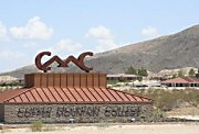
Continue past Copper Mountain Community College (on left).
Go another two miles and look for a tall radio tower on the left side of the road.
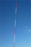
This tower is directly across the highway from the Center.
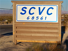
On your right you will see a sign indicating the Center property.
|
|
|